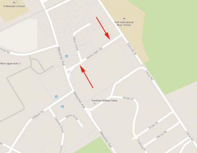
027 Seddul Bahr Road Upper Hutt, street scene 2017
Reason for the name
Seddul Bahr Road was one of the original streets created during the construction of Trentham Military Camp in 1915. It was named after a Turkish village and fortress that was a notable feature of the First World War’s Gallipoli campaign.
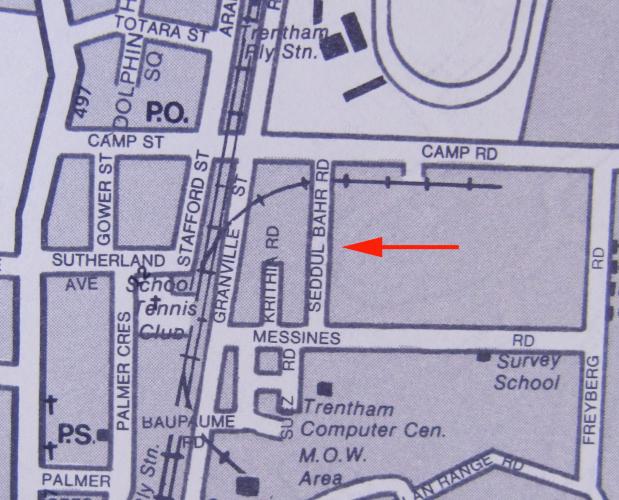
While this original street was subsequently built over during an extensive redevelopment of the Trentham area in the 1980s, the present-day Seddul Bahr Road (known for a time as Anzac Road) occupies approximately the same location. It is the site of the New Zealand Defence Force’s Headquarters Joint Forces.
The origins of Seddul Bahr Road lie in the creation of Trentham Military Camp in late 1914. When the First World War broke out in August of that year New Zealand lacked any permanent military bases. Temporary mobilization camps were set up in the main centres from which the Main Body and First Reinforcements of the New Zealand Expeditionary Force were recruited and trained. On the very same day in October 1914 that these troops embarked for the War, work began on establishing a permanent camp at Trentham. This site was chosen because it was the location of the Dominion Rifle Association’s rifle range and had previously been used by the New Zealand military for training Territorial Units.
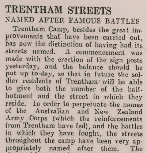
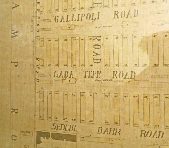
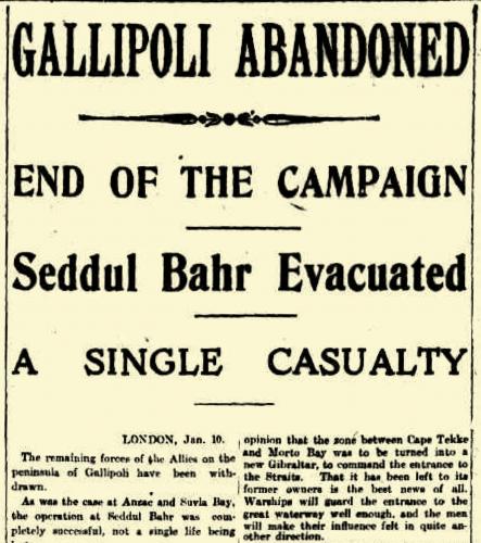
Trentham was originally a “canvas camp” consisting only of tents to accommodate the men. These tents were gradually replaced over the course of 1915 as long wooden hutments were built, each of which could barrack around 100 men. The hutments were arranged as a grid separated into blocks by wide roads. Discussions on what names to give the new roads within the Camp appear to have taken place as early as July 1915. Correspondence from this date between the Chief of General Staff and the Director of Camp and Barracks Construction make reference to a report by a Captain Smith which, amongst other matters, was looking into this issue.1 The end result of this decision making process was publicly announced in an Evening Post article published December 2nd 1915 and headlined: “Trentham Streets Named After Famous Battles” . This noted how sign posts were in the process of being erected to identify the different streets within the camp. These streets had “been very appropriately named” after the “Australian and New Zealand Army Corps (which the reinforcements from Trentham have fed), and the battles in which they have fought.” The article further observed that “[t]he names of the streets should greatly facilitate the working of the camp, and the men appreciate living in streets bearing such imposing titles.”
The names given to the five parallel streets separating the rows of hutments were (in descending order from the railway line): Seddul Bahr Road, Gaba Tepe Road, Gallipoli Road, Sari Bahr Road, and Sulva Road. All of these names memorialized locations associated with New Zealand’s involvement in the Gallipoli Campaign. This campaign had begun with the landings at Anzac Cove on April 25th 1915 and was still in action when these streets were officially given their names in early December. New Zealand troops were finally evacuated from the Gallipoli Peninsula later that month.
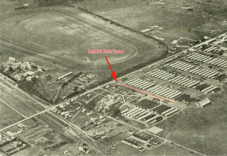
While Trentham Camp underwent several changes after the War the basic street layout appears to have remained the same. A large map of the Camp dated 1932 that hung in Camp Headquarters for many years shows Seddul Bahr Road alongside the other streets with which it was originally created. It survived as a street internal to the Camp through both the major enlargement of the base that occurred during the Second World War and extensive post-War redevelopments up until the 1980s. As late as 1981 Seddul Bahr Road was still being identified on Wise’s Directory’s map of Trentham, even though most of the other original Camp streets had by that stage disappeared
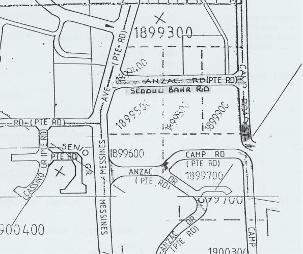
Sometime during the next few years, however, it was replaced by a new street in roughly the same position called Anzac Road. References to this street were made in a 1986 Upper Hutt Leader article which reported that, with the closure of Camp Road as a public access route to Alexandra Road and the planned shift of the Camp entrance to Messines Road, the “newly formed Anzac Road” was being used as a temporary detour.
By 1989, though, as part of this ongoing redevelopment, further changes were made. In a letter dated June 6 of that year the Trentham Camp Commander advises the Heretaunga-Pinehaven Area Engineer at the Upper Hutt City Council that the Department of Survey and Land Information had concerns about the naming of streets in the area.3 These appear to have been to do with the possibility of confusion arising between the names of new streets internal to Trentham Camp, and public access streets outside the Camp’s boundary fence. Since the new access route into the Camp off Messines Road was called Anzac Drive, it was decided to rename Anzac Road which ran outside the camp’s upper perimeter. Noting the tradition of giving Trentham Camp streets and barracks names commemorating World War 1, and also referencing the aforementioned 1932 map of the Camp which indicated Seddul Bahr Road had stood in approximately the same spot as Anzac Road did now, the letter announced that a decision had been made to rename the new roadway after its predecessor. Consequently the link with the original intent to memorialize the association of New Zealand troops with Seddul Bahr during the Gallipoli Campaign was restored.
Author: Reid Perkins Archivist UHCC
About Seddul Bahr and the 1915 Gallipoli Campaign
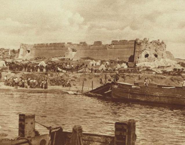
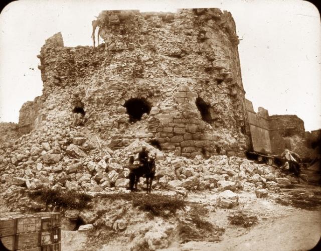
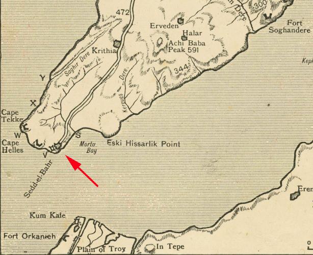
Seddul Bahr is a village and a fortress at Cape Helles on the tip of the Gallipoli Peninsula in Turkey. The fortress, situated in an old castle (originally built in 1659) was a key part of the Ottoman defences guarding the entrance to the strategically important Dardenelles Strait during the First World War. It was heavily bombarded by a British and French naval force during a failed attempt to enter the strait in March 1915. Several weeks later it was one of the principle landing sites of the Allied invasion that marked the beginning of the Gallipoli Campaign. On April 25th, the same day that New Zealand and Australian troops established a beachhead further north on the Gallipoli Peninsula that came to be known as Anzac Cove, British forces landed at Cape Helles, including at the beach alongside Seddul Bahr. While the British managed to take the fortress, and the nearby village, the landing did not go as planned. Casualties were extremely heavy and troops were unable to meet their planned objective of progressing further inland as far as the village of Krithia. Despite subsequent reinforcement by French troops, the Allies were unable to advance far beyond the area around Seddul Bahr and the situation settled into a stalemate of trench warfare.
The specific connection between New Zealand forces and Seddul Bahr arises from one of the attempts made to break this stalemate. In early May 1915 the situation at Anzac Cove was considered sufficiently stable enough for some troops to be spared for the fighting down south. The New Zealand Infantry Brigade was ferried to Cape Helles where they disembarked on the beach alongside Seddul Bahr. The ruins of the old fortress, badly damaged by the Allied naval bombardment, made a striking sight for the new arrivals and was much commented on in their letters and diaries. These men subsequently participated in an assault on the Turkish lines as part of what became known as the Second Battle of Krithia (6-8 May, 1915). On May 8th, in daylight, and with inadequate preparation and artillery support, the New Zealand Infantry Brigade were ordered to attempt to capture Krithia in the face of heavy Turkish rifle and machinegun fire. The results were predictably disastrous and the New Zealanders suffered 835 casualties for no gain. These men later returned to Anzac Cove before the survivors were eventually evacuated in December. When the British and the French departed from Seddul Bahr in January the following year the Gallipoli Campaign finally came to an end.