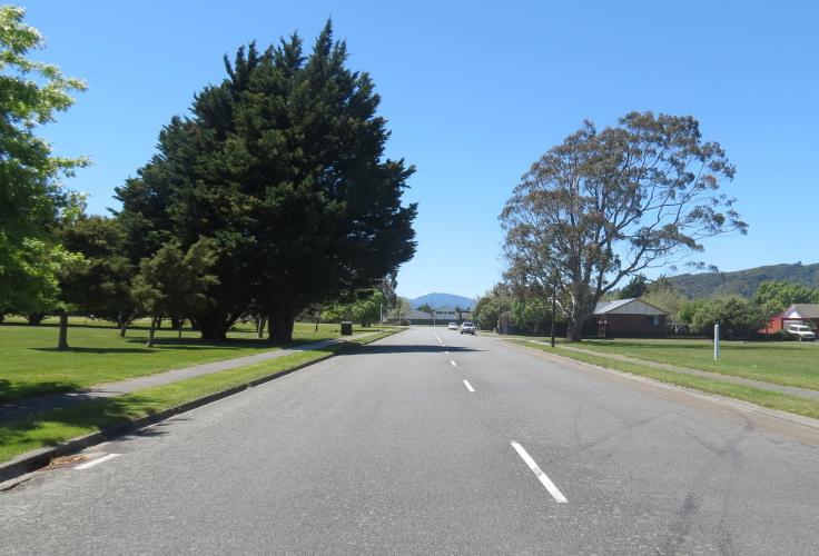
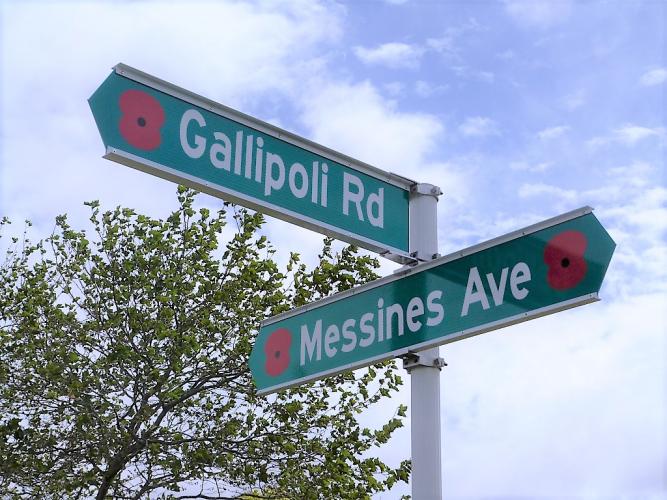
001 Gallipoli Road Upper Hutt, street view 2017
Reason for the name
Upper Hutt’s Gallipoli Road is the remnant of a street originally built in 1915 as part of Trentham Military Camp. It is possibly the first location in this country to be named in honour of the service of New Zealand troops at Gallipoli during the First World War.
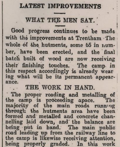
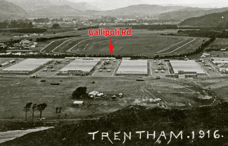
Trentham was originally a “canvas camp” consisting only of tents to accommodate the men. These tents were gradually replaced over the course of 1915 as long wooden hutments were built, each of which could barrack around 100 men. The hutments were arranged as a grid separated into blocks by wide roads. A report in the Evening Post for the 8th September 1915 described the ongoing work involved in constructing the latter. This entailed the use of graders and steam rollers to form the roads, which were then metalled with gravel brought in from the nearby railway siding. Concrete channelling for drainage was also put in place. Altogether 2.2 kilometres of roads were formed and metalled in Trentham Camp between 1915 and 1918.
Author: Reid Perkins Archivist UHCC reid.perkins@UHCC.govt.nz
Discussions on what names to give the new roads within the Camp appear to have taken place as early as July 1915. Correspondence from this date between the Chief of General Staff and the Director of Camp and Barracks Construction make reference to a report by a Captain Smith which, amongst other matters, was looking into this issue.2 The end result of this decision making process was publicly announced in an Evening Post article published December 2nd 1915 and headlined: “Trentham Streets Named After Famous Battles” (see Figure 3). This noted how sign posts were in the process of being erected to identify the different streets within the camp. These streets had “been very appropriately named” after the “Australian and New Zealand Army Corps (which the reinforcements from Trentham have fed), and the battles in which they have fought.” The article further observed that “[t]he names of the streets should greatly facilitate the working of the camp, and the men appreciate living in streets bearing such imposing titles.”
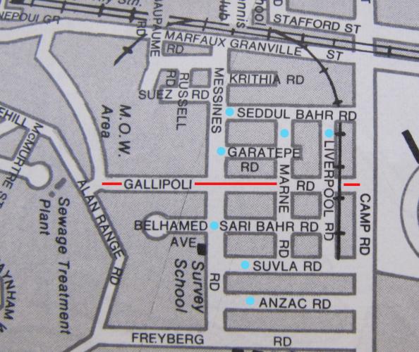
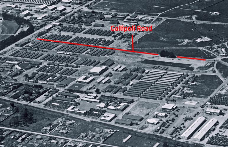
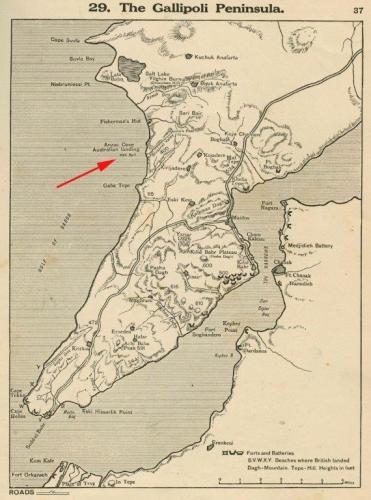
The names given to the five parallel streets separating the rows of hutments were (in descending order from the railway line): Seddul Bahr Road, Gaba Tepe Road, Gallipoli Road, Sari Bahr Road, and Sulva Road. All of these names memorialized locations associated with New Zealand’s involvement in the Gallipoli Campaign. This campaign had begun with the landings at Anzac Cove on April 25th 1915 and was still in action when these streets were officially given their names in early December. New Zealand troops were finally evacuated from the Gallipoli Peninsula later that month.
Upper Hutt’s Gallipoli Road is the remnant of a street originally built in 1915 as part of Trentham Military Camp. It is possibly the first location in this country to be named in honour of the service of New Zealand troops at Gallipoli during the First World War.
The origins of Gallipoli Road lie in the creation of Trentham Military Camp in late 1914. When the First World War broke out in August of that year New Zealand lacked any permanent military bases. Temporary mobilization camps were set up in the main centres from which the Main Body and First Reinforcements of the New Zealand Expeditionary Force were recruited and trained. On the very same day in October 1914 that these troops embarked for the War, work began on establishing a permanent camp at Trentham. This site was chosen because it was the location of the Dominion Rifle Association’s rifle range, which had previously been used by for training Territorial Units following the introduction of Compulsory Military Training in 1912.
Trentham was originally a “canvas camp” consisting only of tents to accommodate the men. These tents were gradually replaced over the course of 1915 as long wooden hutments were built, each of which could barrack around 100 men. The hutments were arranged as a grid separated into blocks by wide roads. A report in the Evening Post for the 8th September 1915 described the ongoing work involved in constructing the latter (see Figure 2). This entailed the use of graders and steam rollers to form the roads, which were then metalled with gravel brought in from the nearby railway siding. Concrete channelling for drainage was also put in place. Altogether 2.2 kilometres of roads were formed and metalled in Trentham Camp between 1915 and 1918.1
Discussions on what names to give the new roads within the Camp appear to have taken place as early as July 1915. Correspondence from this date between the Chief of General Staff and the Director of Camp and Barracks Construction make reference to a report by a Captain Smith which, amongst other matters, was looking into this issue.2 The end result of this decision making process was publicly announced in an Evening Post article published December 2nd 1915 and headlined: “Trentham Streets Named After Famous Battles” (see Figure 3). This noted how sign posts were in the process of being erected to identify the different streets within the camp. These streets had “been very appropriately named” after the “Australian and New Zealand Army Corps (which the reinforcements from Trentham have fed), and the battles in which they have fought.” The article further observed that “[t]he names of the streets should greatly facilitate the working of the camp, and the men appreciate living in streets bearing such imposing titles.”
The names given to the five parallel streets separating the rows of hutments were (in descending order from the railway line): Seddul Bahr Road, Gaba Tepe Road, Gallipoli Road, Sari Bahr Road, and Sulva Road. All of these names memorialized locations associated with New Zealand’s involvement in the Gallipoli Campaign. This campaign had begun with the landings at Anzac Cove on April 25th 1915 and was still in action when these streets were officially given their names in early December. New Zealand troops were finally evacuated from the Gallipoli Peninsula later that month.
While Trentham Camp underwent several changes after the War the basic street layout appears to have remained the same. A large map of the Camp dated 1932 that hung in Camp Headquarters for many years shows Gallipoli Road along with the other streets retaining the same grid formation as they had when first created.3 By the time of the Second World War, however, when Trentham Camp again came into extensive use and was greatly expanded, aerial photographs indicate that Gallipoli Road had been extended in a straight line well beyond the original grid of hutments.
In the decades immediately following that war this arrangement seems to have become a permanent fixture. A map of the area from the 1980 Wise’s Directory shows all the original Trentham Camp streets still in place but with Gallipoli Road, alone of these, stretching well beyond the original Camp perimeter. Soon after this map was made the area underwent a major redevelopment. This involved new streets being built, others being lengthened or realigned, and the military camp itself greatly reducing in the size. Within the new Camp bounds all the old 1915 streets were demolished.
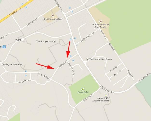
The only remnant of these streets that now exists is the extended section of Gallipoli Road that falls outside the present perimeter fence. This retains the connection with the building of the original Trentham Camp and the tribute made at that time through naming its streets in honour of the men then serving in the Gallipoli Campaign.
- New Zealand Defence Force Heritage Inventory: Trentham Military Camp (May 2010), p. 1
- Archives NZ Wellington ref: AAYS 8697 AD812 4/18 Construction at Trentham Camp 1915-1919
- 1933 Map of Trentham Camp on display at WW1: Tracing the Footsteps from Trentham exhibition on display at Expressions Gallery, Upper Hutt, August-October 2014.
The New Zealand Expeditionary Force which left Wellington in October 1914 was originally expected to be headed for the Western Front. All that changed, however, when later that month the Ottoman Empire entered the War on the side of Germany. The newly arrived New Zealand and Australian troops were now directed instead, firstly, to Egypt to help protect the Suez Canal, and then onto the Greek island of Lemons to prepare for a planned invasion of Turkey’s Gallipoli Peninsula. The intention here was to capture the strategically important Dardanelles Straits which would open the way to taking Constantinople, the Ottoman capital. As well as defeating Germany’s ally this would create the possibility of reinforcing Russia on the Eastern Front.
New Zealand and Australian troops – who would come to be known as Anzacs during this campaign – comprised nearly half of the Allied forces participating in the invasion launched on April 25th, with British and French forces landing in the south of the Peninsula and New Zealand and Australian forces in the north. The landings did not go as planned, however, with the Australian and New Zealanders finding themselves trapped by mistake on a small beach surrounded by steep hills that became known as Anzac Cove. Like the British and French forces the Anzacs managed to establish a beachhead but, pinned down by Ottoman forces, were unable to progress any further.
This situation continued for several months with significant losses on both sides. In August, in an attempt to break this stalemate, the Allies undertook a major offensive which led to New Zealand troops capturing the hill known as Chunuk Bair. This was to be the Allies’ furthest advance into the Peninsula, however, and they were eventually forced back onto the beaches. By November the British High Command realised the invasion had failed and planned for an evacuation, which was successfully undertaken in late December.
In military terms the Gallipoli Campaign was a costly failure for the Allies, with over 44,000 deaths. 2779 of these were New Zealanders, which represented almost one-in-five of those who fought there. This high toll had a huge impact on what was a very small country; at the same time the efforts of these men in such trying circumstances became a major source of national pride. As with Australia, the Gallipoli Campaign served as a watershed moment in forging a national identity for New Zealand separate from that of belonging to the British Empire.
Upper Hutt has particularly strong connection with what happened at Gallipoli because of the founding of Trentham Military Camp. While the New Zealand troops who first landed at Anzac Cove had left before the Camp was created, the subsequent reinforcements to the Peninsula (from the 2nd to the 6th NZEF Reinforcements) had almost all been trained at Trentham, representing in excess of 10,000 men. The naming of the streets within the Camp was an important recognition of this fact. As well as that, like the rest of New Zealand, several of those who died at Gallipoli had come from Upper Hutt or had strong family or work links to the area. These included John Geange, member of a prominent local family, who had received multiple bullet wounds at Gallipoli and was invalided home but subsequently died from his injuries; Upper Hutt born and raised William Minchin; Sergeant Stan Moore of Kaitoke; and Wellington-born Captain Alfred Shout, whose parents lived in Upper Hutt and who posthumously won the Victoria Cross at Gallipoli while serving with the Australian Infantry.